Project Highlights
Global Seamounts Project
Spatiotemporal Measurements Over Seamounts
Oscar Schofield, PhD
Distinguished Professor; Chair, Department of Marine and Coastal Sciences, Rutgers University’s Center of Ocean Observing Leadership (RU COOL)
School of Environmental and Biological Sciences
Rutgers University, New Brunswick, NJ USA
The biophysical modeling work of the Global Seamounts Project (GSP) will require that GSP Field Campaign expeditions measure temporal biogeochemical and productivity fluxes for selected project sites, over multiple seasonal periods. A combination of autonomous gliders, stationary moorings, and benthic landers deployed by GSP vessels and left on site for between six to twelve months are planned to achieve this.
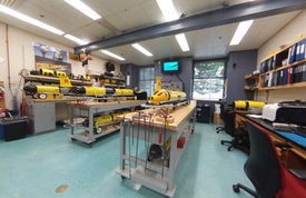
For the autonomous glider component of the project, the Center for Ocean Observing Leadership (COOL) at the Institute of Earth, Ocean and Atmospheric Sciences at Rutgers University, in New Brunswick, New Jersey, USA has proposed to build and technically support Slocum Gliders for the GSP (four new dedicated gliders are proposed for the project - Figure 1) and to provide continuous monitoring and data management from COOL’s Mission Control Center at Rutgers University.
The Center is supported with extensive computing facilities and data distribution systems for a wide range of ongoing ocean and atmospheric research and modeling (Figure 2).
Repeat GSP ship surveys will be conducted during different seasonal periods on a sub-set of GSP survey sites in the Pacific, Atlantic and Indian Oceans, with the number and location of repeated sites to be finalized during upcoming GSP Workshops. All repeat survey sites will be candidates for leave-behind, long-term glider surveys as they can be picked up on later site visits or steered by satellite to a pick-up site on shore, depending on location of the study site.
Slocum Gliders have been operated by Rutgers University since 1999, with sustained deployments by the COOL Operations Center beginning in 2003. Since then, these gliders have logged over 260,000 km of sampling in remote places around the world including in Antarctica, Alaska, South Africa, Brazil, Sri Lanka, and Norway.
Payloads & Sensor Arrays
Slocum Gliders are unmanned systems that propel themselves through the water by modifying their buoyancy and using their wings to glide in a sawtooth pattern through the water column along a subsurface transect. At user specified intervals, the glider surfaces, transmits its data to shore via an Iridium satellite system, and checks for new directions or missions (Figure 3). Long duration versions of Slocum Gliders are capable of more than 1 year of continuous flight.
Glider science payload bays can host a wide range of sensors and instruments, including conductivity temperature and depth (CTD) sensors, fluorometers, backscatter sensors, hyperspectral spectrophotometer, pH sensors, Fluorescence Induction and Relaxation (FIRe) sensors, acoustic Doppler current profilers (ADCPs), acoustic echosounders for zooplankton, turbulent microstructure sensors, Laser In Situ Scattering, oxygen sensors (Figure 4), and Transmissometry for particle size and concentration. The number and selection of sensors that can be carried is a function of mission design and duration.
The GSP proposes to measure a range of biogeochemical parameters that are inter-calibrated across multiple seamount systems, including from sampled sites where temporal data can represent diurnal and seasonal cycles.


